SLANTRANGE
Powerful New Information Tool for Agriculture
“Slow and low” aircraft, like the small unmanned aerial systems (sUAS), provide a platform for entirely new types of agricultural measurement and information – information that cannot be captured by satellites, manned aircraft, or ground-based systems.
But delivering on that potential requires innovation.
Measurements must be accurate to be trusted by growers, or to have any relevance to downstream data models. That means important vegetation signals must be separated from the background clutter and normalized for changing environmental conditions.
Analytical systems must be versatile enough to address the very specific information needs of growers across an incredibly diverse industry.

The cost of data collection, processing, and information delivery must be drastically reduced so that the benefits of these new types of information can accrue even to smallest farmers in the most remote regions of the world.
SLANTRANGE, possibly the most powerful information tool the farm has ever seen is addressing each of those challenges with technical innovations in remote sensing hardware systems, new computer vision and artificial intelligence analytics, and in the network architectures for how data is collected, processed, and distributed.
The SLANTRANGE Product Family
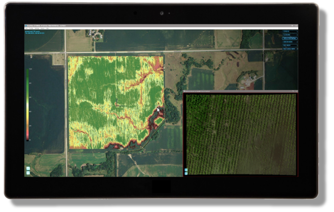
Immediate Analytics. Anywhere.
The SlantView analytics platform delivers the information you need at the time and place you need it. That means pushing powerful analytics tools out and away from the cloud and into the field where your decisions need to be made – an entirely new approach to crop measurement and analysis.
What does that mean for you?
Valuable new classes of information
Immediate, on-site results without any need for network connectivity
Far more efficient workflows for lower operational costs
Exportable data to be shared wherever, whenever, and however you’d like

Powerful, Accurate New Measurement Systems
New for 2017, we introduce the most powerful on-board processing system in the industry for immediate, in-field results. Built around the Qualcomm Snapdragon processor, the SLANTRANGE 3p multispectral sensor extends advanced analytics to all of the world’s agricultural acres, not just those within easy reach of a fast internet connection.
Reduce operational costs with up to 4x the area coverage rate of comparable sensors
Unmatched radiometric accuracy with integrated position, attitude, and sunlight measurement sensors first introduced and patented by SLANTRANGE
Designed to be integrated on virtually any small drone
SlantRange 3p Multispectral Sensor

Powerful On-Board Analytics
Built around the Qualcomm Snapdragon processor, the SLANTRANGE 3p includes powerful new on-board image processing and analytics capabilities, providing the next generation of accuracy and speed you’ve come to expect from SLANTRANGE.
4x More Area Per Flight
Costs matter. And for small UAS operators that means the need to survey more acres per hour, more acres per flight.
The SLANTRANGE 3p’s innovative processing algorithms require only 20% image overlap, even when operating in late season row crops. Compare that to 80% overlap required by traditional processing methods – 4x less time and money spent collecting data.
Instant Results. Anywhere. Any Time.
No network required. No high-end computer required.
The SLANTRANGE 3p starts the processing on-board, while still in flight. Complete, full-product field results are available within a few minutes of landing.
If you need to operate in areas with limited to zero network or computing accessibility, or don’t have the time to upload or process your own data, the SLANTRANGE 3p is for you.
Always Accurate
Accuracy is essential. It is the difference between trusting the measurements you paid for, or wondering if those subtle changes in the data are actually just a result of inaccurate sensors or improperly combined sensors and software.
SLANTRANGE pioneered, and patented, a new approach to measurement accuracy with the introduction in 2014 of on-board, band-matched solar characterization and radiometric calibration.
The SLANTRANGE 3p is even more accurate. Innovative new design elements run together through the integrated hardware/software architecture to deliver the most accurate measurements available for small aircraft:
Integrated solar spectrometer for frame-to-frame radiometrically accurate reflectance measurements (US Patent 9,470,579)
Individual lens characterization for precise dewarping and de-vignetting
Optimized algorithms for dynamic cross-channel registration
Smart Filtering™, which selectively samples scene elements to avoid the contaminating effects of background soils, shadows, specular reflections, or other noise sources.
Altogether, these new capabilities make the 3p the most accurate aerial vegetation measurement system available.
For Use on Virtually Any Aircraft
With integrated sunlight calibration, GPS, and inertial measurement units (IMU), the SLANTRANGE 3p can be operated on virtually any aircraft. All that’s required for integration is a power source and mounting location. Smart analytics eliminate the need for gimbals or vibration isolation systems for the ultimate in simplicity. Ask us about installation kits for many common aircraft types.
Technical Specification
Spectral Channels (Vegetation Sensor)
Spectral Channels (Ambient Illumination Sensor)
Processor Type
Processor Speed
On-Board RAM
Detector Type
Available Spectral Range
Band Positions
Shutter Type
Positioning & Pointing
GSD @ 120 m AGL
Recommended Image Overlap
Linear Coverage Rate @ 120 m AGL, 20 m/s
160 Acre Survey @ 120 m AGL, 20 m/s
Available Information Layers
On Board Data Storage (Removable)
Output Formats
Size (Vegetation Sensor)
Size (Ambient Illumination Sensor)
Weight
Power
4
4
Qualcomm Snapdragon 801
Quad-Core 2.26GHz
2 GB
Si CMOS
410 - 950 nm
Selectable
Global
Integrated GPS/IMU with Extended Kalman Filter
4.8 cm
20%
1,000 Acres/Hour
17 Minutes
Population Density, Population Size Distributions, Weed Coverage, Stress, Vegetation Fraction, Yield Potential, GNDVI, RNDVI, Red Edge NDVI, Color, User-Defined Smart Detection
64 GB (4 hours)
KML, SHP, GeoTIFF
14.6 x 6.9 x 5.7 cm
8.1 x 3.5 x 1.7 cm
350 g
11 W @ 9.0-28.0 VDC
Notes:
• Band positions are selectable at time of order between 410 – 950 nm, and may be reconfigured by factory. Some conditions apply.
• Populations and Weeds data layers are applicable to specific crop types and stages of growth.
DOWNLOAD SLANTRANGE PRODUCT GUIDE 2017

PURCHASE
Southern Cross Drones are Resellers / Distributors for SlantRange multispectral sensors in Australia, New Zealand and APAC regions. For more information about SlantRange products and to purchase contact us by sending request to info@southerncrossdrones.com
Copyright © 2024 Southern Cross Drones Pty Ltd . All Rights Reserved